When creating a scenario, the software provides the option of generating a separate file that contains the raw data of the generated scenario file. The software saves the raw data as a csv file in the same location as the generated scenario file and uses the same file name with the appended text _constellation abbr_raw_data, for example; newScenario_bds_raw_data.csv. The following list shows the constellation abbreviations:
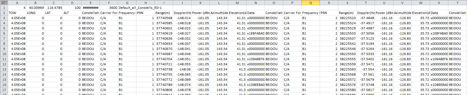
The software creates the raw data in separate files for each constellation type, and the raw data file is pre-formatted to show the data for any of the satellites in the constellation that are visible to the receiver. In addition to the satellite data, the file shows the time-of-week (TOW). While the file also shows a column for longitude, latitude, and altitude populated with zeros, these columns do not represent any real data and are reserved for future use. The following figure shows a small part of a Beidou raw data file.
Figure 1: Raw Scenario Data
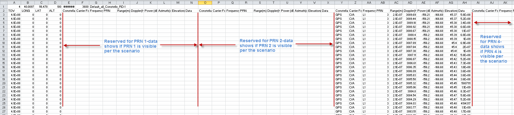
The information type for each satellite is the same and spans over 10 columns, with the first column being the constellation. As stated earlier, the files are always pre-formatted to show the data for any of the satellites in the constellation that are visible to the receiver:
The file maintains a fixed ascending PRN numbering display where PRN 1 always resides in the first group of 10 columns of satellite information, PRN 2, in the second group of 10 columns, and PRN 3 in the third group of 10 columns. This PRN numbering location in the spreadsheet continues to the last PRN. This is shown in Figure 2 below for the GPS raw data file, where the first two groups of 10 columns, reserved for PRN 1 and PRN 2, are blank, and PRN 3 data shows in the third group of 10 columns. If PRN 4 was visible in the scenario, the data would show in the fourth group of 10 columns, and so on.
Figure 2: Raw Scenario Data Placement
The software supports a maximum of 56 channels to accommodate multiple constellation scenarios. GPS, GLONASS, and Beidou share 40 channels, and Galileo can use up to 16 channels. The output raw scenario data file supports up to 32 satellites for GPS, up to 24 satellites for GLONASS, and up to 30 satellites for Galileo and Beidou, 20 satellites for SBAS and 5 satellites for QZSS.
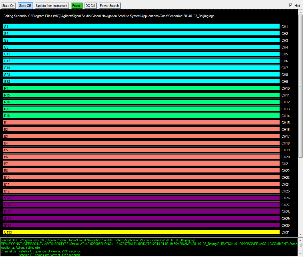
With so many satellites and different satellites becoming visible at different times during the scenario, especially when using multiple constellations, it may become challenging to read the data. This is where the Scenario Graphics node can help.The scenario graphic is a visual representation of the raw data, which can be used to help correlate the data. It shows satellite visibility vs. time along the x-axis (shown in Figure 3) in the scenario, and it can be used to help locate the information for a particular satellite in the raw data file.
After creating a scenario, the Scenario Graphics node displays all of the satellites used in the scenario. Each constellation type is identified by a letter prior to the SV ID and a color:
'G' for GPS with a blue background
'R' for GLONASS with a green background
'E' for Galileo with an orange background
'B' for Beidou with a red background
'S' for a SBAS with a purple background
Figure 3: Scenario Graphics
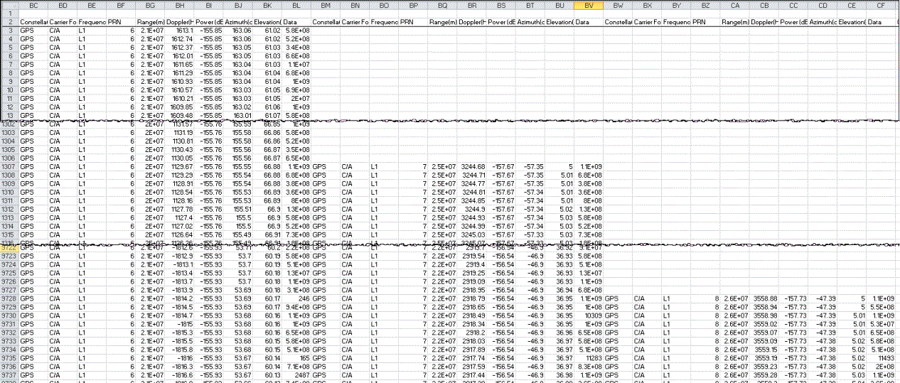
As with the scenario graphics, the data in the raw data file also follows when the satellite becomes visible. When a satellite is visible at the beginning of the scenario, its data starts on the first available data row (row 3 shown in Figure 4). If the satellite becomes visible later in the scenario, its data starts further down in the rows. Where it starts in the rows is dependent upon when it becomes visible to the receiver. Figure 4 demonstrates this concept. It shows some of the GPS raw data from the above Scenario Graphics figure (Figure 3).
Figure 4 shows that GPS PRN 6, on channel 12 in the scenario graphics, is visible at the beginning of the scenario at an elevation of 61.02 degrees, and GPS PRN 7, on channel 24 in the scenario graphics, becomes visible later in the scenario at row 1307 with an elevation of 5 degrees, the set value for the Elevation Mask Angle. Then GPS PRN 8, on channel 13 in the scenario graphics, becomes visible still later in the scenario at row 9728, at the set Elevation Mask Angle. The raw data also shows when a satellite is no longer visible by ending the data. This typically occurs when the satellite drops below the Elevation Mask Angle.
Figure 4: Scenario Data Placement over Three Satellites